Skip to content
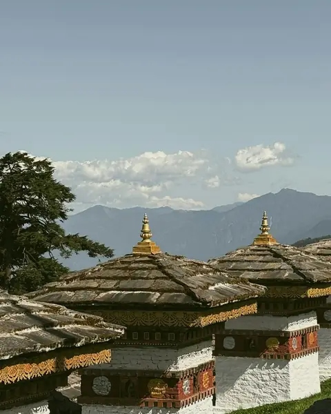
Chortens on a grassy hill with mountains beyond, at Dochula Pass

Thimphu & Punakha districts

Dochula Pass & Punakha

A mountain pass lined with 108 memorial chortens, with Himalayan views on clear days and a grand dzong below.

Altitude
3,100 m
Best months
Mar–Apr · Oct–Nov
Level
Easy
Fly into
Paro (PBH)

Overview

Dochula Pass, at about 3,100 m on the road between Thimphu and Punakha, is the best-known viewpoint on Bhutan's main east–west road. The 108 Druk Wangyal Chortens, built at the order of Queen Ashi Dorji Wangmo Wangchuck to honour Bhutanese soldiers who died in the conflict of December 2003, were completed in 2004 and frame views across the eastern Himalaya on clear days.

Peaks including Masang Kang (7,194 m) and Gangkhar Puensum (7,570 m), Bhutan's highest mountain, can be seen from the pass on the clearest days, mostly in the cooler months. Below the pass, the road descends to the warm Punakha valley, where Punakha Dzong stands at the meeting of the Pho Chhu and Mo Chhu rivers.

Highlights

  • The 108 Druk Wangyal Chortens, with prayer flags and mountain views
  • Clear-day views of the eastern Himalaya, including Gangkhar Puensum (7,570 m)
  • Punakha Dzong, built in 1637 where two rivers meet
  • Chimi Lhakhang, a temple reached by a short walk through rice fields, and the Punakha suspension bridge

Best time to visit

October to March are the best months for views from the pass, with the clearest skies after the monsoon, though mornings are very cold. March and April bring rhododendron blossom on the upper slopes, and the Punakha valley is warm in winter. Summer monsoon cloud often hides the peaks. The Druk Wangyal Festival takes place at the pass on 13 December each year.

  1. JanJanuary: Not ideal
  2. FebFebruary: Good
  3. MarMarch: Best
  4. AprApril: Best
  5. MayMay: Good
  6. JunJune: Not ideal
  7. JulJuly: Not ideal
  8. AugAugust: Not ideal
  9. SepSeptember: Good
  10. OctOctober: Best
  11. NovNovember: Best
  12. DecDecember: Good

● Best · ○ Good · blank: not ideal. Conditions vary by year, so check local forecasts and access before you go.

Getting there

Fly to Paro (PBH). Thimphu, the capital, is roughly an hour from the airport by road, and Dochula Pass lies about 30 km beyond Thimphu on the road to Punakha. Punakha is another one to two hours further, down into a warmer valley. Most visitors travel with a driver and guide arranged through a tour operator; check bhutan.travel for current visa, fee and guide requirements.

What to expect

Easy: a roadside stop with a short walk among the chortens, and a café and temple at the pass. The road is winding and can be foggy. Allow a morning at the pass and a half day in Punakha. The pass is cool even in summer, and the valley below is warm.

Practical tips

  • Stop on the way up from Thimphu, ideally in the morning, for the clearest views.
  • Bring a warm jacket: the pass is windy and cold, even when the valley is mild.
  • Walk clockwise around chortens and prayer wheels, as Bhutanese Buddhists do.
  • Check road conditions in winter and during the monsoon; fog, landslides and snow can delay journeys.

Frequently asked questions

Can you see Mount Everest from Dochula Pass?

No. The peaks visible from Dochula are in Bhutan's eastern Himalaya, including Gangkhar Puensum. Everest is much farther away.

Who built the 108 chortens at Dochula?

They were commissioned by Queen Ashi Dorji Wangmo Wangchuck to honour soldiers who died in the conflict of December 2003, and were finished in 2004.

When is the best time to visit Punakha?

Spring and autumn are the most popular seasons, and winter is mild in the valley. Check festival dates, which can bring crowds.

Official sources

Rules, fees, permits and conditions change. Check the official pages below before you travel.

Last reviewed October 2026. Details are for planning only and can change; confirm access, permits and conditions with official sources before you travel. Spotted something out of date? Tell us. Photography: Rama Krushna Behera on Unsplash.

Where to stay

Where to stay in Dochula Pass & Punakha

Hotels in Dochula Pass & Punakha are coming soon

We are adding the hotels, guesthouses and lodges that local owners register with us. Each one is reviewed before it appears here. Meanwhile, you can compare stays on our partner sites.

List your hotel Compare stays (opens a partner site in a new tab)

More in Bhutan

Keep exploring Bhutan

The Tiger's Nest monastery clinging to a cliff above a pine forest

Paro District, western Bhutan

Tiger's Nest (Paro Taktsang)

A Buddhist monastery clinging to a cliff about 900 m above the Paro valley, reached by a steep half-day hike.

3,120 m · Mar–May · Sep–Nov · Moderate

Good for: Villages & culture · Trekking

Tashichho Dzong in the Thimphu valley below forested hills

Thimphu District

Thimphu

A small capital of traditional wooden architecture and no traffic lights, set in a high valley.

2,320 m · Mar–May, Sep–Nov · Easy

Good for: Villages & culture · Scenic views

Jakar Dzong on a hillside above the Bumthang valley

Bumthang District

Bumthang

A cluster of four high valleys with some of the oldest temples and monasteries in the country, set among meadows and forests.

2,600 m · Mar–May, Sep–Nov · Easy

Good for: Villages & culture · Scenic views · Trekking

The wide glacial Phobjikha valley with a village and mountains beyond

Wangdue Phodrang

Phobjikha and Gangtey

A wide, glacier-carved valley where black-necked cranes spend the winter, below the Gangtey Monastery.

3,000 m · Nov–Mar, Sep–Oct · Easy

Good for: Villages & culture · Scenic views · Trekking

A bridge and a forested peak in the Haa Valley

Haa District

Haa Valley

A quiet valley west of Paro that opened to visitors only in 2002, with temples, meadows and the Chele La pass.

2,700 m · Mar–Jun, Sep–Nov · Easy

Good for: Villages & culture · Scenic views · Trekking

Prayer flags on the ridge at Chele La Pass above Paro

Paro and Haa

Chele La Pass

A high road pass hung with prayer flags, with views of Jomolhari and the Haa Valley on clear days.

3,988 m · Mar–Jun, Sep–Nov · Easy

Good for: Scenic views · Trekking

Snow-covered Jomolhari above brown ridges in western Bhutan

Paro District

Jomolhari Trek

A multi-day trek beneath Jomolhari, a 7,326 m peak sacred in Bhutan, through yak pastures and remote valleys.

4,930 m · Apr–Jun, Sep–Oct · Challenging

Good for: Trekking · Scenic views · Villages & culture

Trongsa Dzong on a ridge above forested slopes in central Bhutan

Trongsa District

Trongsa

A huge dzong on a ridge above the Mangde Chhu gorge, the ancestral home of Bhutan's royal family.

2,200 m · Mar–May, Sep–Nov · Easy

Good for: Villages & culture · Scenic views

Gasa Dzong on a hilltop below snow peaks in northern Bhutan

Gasa District

Gasa and Gasa Tshachu

A remote northern district with a hilltop dzong and well-known hot springs, close to the start of the Snowman Trek.

2,800 m · Mar–May, Sep–Nov · Moderate

Good for: Villages & culture · Scenic views · Trekking

A glacial lake below rocky peaks on the Dagala trail

Thimphu District

Dagala Thousand Lakes

A short trek to a high plateau of glacial lakes, with views of the Himalayan range, close to Thimphu.

4,720 m · Apr–Jun, Sep–Oct · Challenging

Good for: Trekking · Lakes · Scenic views

Trashigang Dzong on a ridge above the Gamri river valley in eastern Bhutan

Trashigang District

Trashigang

A hill town in eastern Bhutan with a large dzong above the Gamri river, a base for the remote east.

1,100 m · Mar–May, Sep–Nov · Easy

Good for: Villages & culture · Scenic views