Skip to content
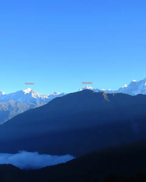
A clear view of Himalayan peaks from the Tungnath ridge near Chopta

Uttarakhand

Chopta and Tungnath

A meadow and the world's highest Shiva temple, reached by a short, steep trek with views of the Garhwal Himalaya.

Altitude
3,680 m
Best months
Mar–Jun, Sep–Nov
Level
Moderate
Fly into
Dehradun (DED)

Overview

Chopta is a small meadow in Uttarakhand, about 2,680 m, surrounded by deodar and rhododendron forest, and sometimes called the Mini Switzerland of India. It is the starting point for the trek to Tungnath, at about 3,680 m, one of the Panch Kedar temples and often described as the highest Shiva temple in the world.

The path to Tungnath is about 3.5 km, a steady climb that takes two to three hours, with views of the Chaukhamba, Nanda Devi and Trishul peaks. From the temple, a further 1.5 km climb leads to Chandrashila, at about 4,000 m, with a 360-degree panorama. In winter, the area is under snow, and the temple moves to a lower village.

Highlights

  • The Tungnath temple, one of the highest in the world
  • Chandrashila summit and its 360-degree view
  • Chopta meadows and rhododendron forest
  • Sunrise views of the Himalayan peaks

Best time to visit

March to June and September to November are the best times. April and May bring rhododendron blossom. The monsoon, July and August, has rain and landslides. Winter is snow-covered, with the Tungnath temple closed and the trek limited.

  1. JanJanuary: Not ideal
  2. FebFebruary: Not ideal
  3. MarMarch: Good
  4. AprApril: Best
  5. MayMay: Best
  6. JunJune: Good
  7. JulJuly: Not ideal
  8. AugAugust: Not ideal
  9. SepSeptember: Best
  10. OctOctober: Best
  11. NovNovember: Good
  12. DecDecember: Not ideal

● Best · ○ Good · blank: not ideal. Conditions vary by year, so check local forecasts and access before you go.

Getting there

Fly to Dehradun (DED), then drive about 7 to 8 hours via Rishikesh and Rudraprayag to Chopta. Buses run to Ukhimath, and taxis cover the final stretch. Accommodation is simple, with camps and guesthouses. Book ahead in peak season.

What to expect

Moderate. The trek is short but steep, and altitude can cause tiredness. Cold winds at the top are strong, so carry layers. In winter, snow makes the trail challenging.

Practical tips

  • Check road and weather conditions, especially in the monsoon.
  • Start early to see the sunrise from Chandrashila and avoid afternoon cloud.
  • Take warm layers, a windproof jacket and good shoes.
  • Respect the temple and the surrounding environment.

Frequently asked questions

How long is the Tungnath trek?

About 3.5 km each way, taking two to three hours up.

Is Chandrashila difficult?

It is a steep extra 1.5 km, but most fit walkers can do it.

When is Tungnath open?

Usually from April or May to November, closing in winter.

Official sources

Rules, fees, permits and conditions change. Check the official pages below before you travel.

Last reviewed October 2026. Details are for planning only and can change; confirm access, permits and conditions with official sources before you travel. Spotted something out of date? Tell us. Photography: Padmanabhan07 (CC BY-SA 4.0) via Wikimedia Commons.

Where to stay

Where to stay in Chopta and Tungnath

Hotels in Chopta and Tungnath are coming soon

We are adding the hotels, guesthouses and lodges that local owners register with us. Each one is reviewed before it appears here. Meanwhile, you can compare stays on our partner sites.

List your hotel Compare stays (opens a partner site in a new tab)

More in India

Keep exploring India

A hilltop monastery village above a river in the Spiti Valley

Himachal Pradesh, Himalaya

Spiti Valley

A high-altitude cold desert of ancient monasteries, remote villages and very high mountain roads.

3,650 m · Jun–Sep · Moderate

Good for: Villages & culture · Scenic views

A blue poppy in bloom, beaded with rain, in the Valley of Flowers

Uttarakhand, Garhwal Himalaya

Valley of Flowers

A high Himalayan valley that bursts into bloom after the monsoon, reached on a trek from Govindghat via Ghangaria.

3,350–3,650 m · Jul–Sep · Moderate

Good for: Trekking · Scenic views

Namgyal Tsemo gompa on a rocky ridge above Leh in Ladakh

Ladakh

Leh and Ladakh

A high-altitude desert of monasteries, palaces and mountain passes, reached by one of the highest roads in the world.

3,500 m · Jun–Sep · Moderate

Good for: Villages & culture · Scenic views · Trekking

The deep blue Pangong Lake below bare mountains in Ladakh

Ladakh

Pangong Tso

A long, brackish lake at over 4,000 m that shifts between blue, green and grey, straddling the border with Tibet.

4,350 m · Jun–Sep · Moderate

Good for: Lakes · Scenic views

Bactrian camels crossing the sand dunes of the Nubra Valley below snow peaks

Ladakh

Nubra Valley

A high valley north of Leh, with sand dunes, double-humped camels, monasteries and the highest motorable road in the world nearby.

3,050 m · Jun–Sep · Moderate

Good for: Scenic views · Villages & culture

Snow-capped mountains above a meadow and huts in the Solang Valley near Manali

Himachal Pradesh

Manali and Solang Valley

A busy hill station in the Beas valley, with meadows, forests, snow slopes and adventure sports.

2,050 m · Mar–Jun, Sep–Nov · Easy

Good for: Scenic views · Snow & ski · Trekking

Green meadows with grazing sheep and pine forest at Gulmarg

Jammu and Kashmir

Gulmarg

A high meadow below the Affarwat range, famous for its gondola, which rises to almost 4,000 m, and its skiing.

2,650 m · Dec–Mar, Apr–Jun · Moderate

Good for: Snow & ski · Scenic views · Trekking

Kangchenjunga glowing at sunrise seen from Darjeeling

West Bengal

Darjeeling

A colonial hill station among tea gardens, with a narrow-gauge railway and views of Kangchenjunga on clear mornings.

2,042 m · Mar–May, Oct–Nov · Easy

Good for: Scenic views · Villages & culture

A jeep on the road through the Yumthang Valley with prayer flags and snow peaks

Sikkim

Yumthang Valley

A high valley of rhododendrons and hot springs in North Sikkim, ringed by snow peaks and cut by the Lachung river.

3,564 m · Mar–Jun · Moderate

Good for: Scenic views · Trekking

A boulder on the Triund ridge above Dharamshala under the Dhauladhar range

Himachal Pradesh

Dharamshala and Triund

The home of the Tibetan government-in-exile and a short trek to a ridge beneath the Dhauladhar range.

2,828 m · Mar–Jun, Sep–Nov · Moderate

Good for: Trekking · Villages & culture · Scenic views

The village of Kalpa below the snow peaks of Kinnaur Kailash

Himachal Pradesh

Kinnaur and Kalpa

A high valley of apple orchards and old wooden temples, with Kinnaur Kailash across the river from the village of Kalpa.

2,960 m · Apr–Jun, Sep–Nov · Moderate

Good for: Scenic views · Villages & culture · Trekking