Skip to content
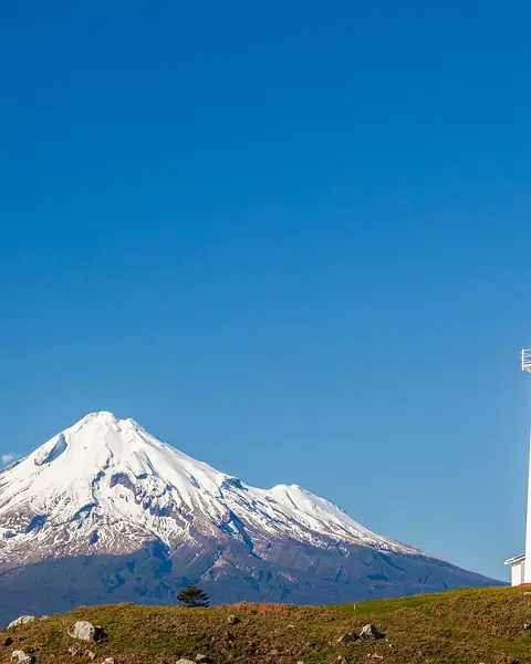
Snow-capped Mount Taranaki behind the Cape Egmont lighthouse

Taranaki, North Island

Mount Taranaki

A symmetrical, snow-capped volcano rising from the coastal farmland of the west of the North Island.

Altitude
2,518 m
Best months
Nov–Apr
Level
Challenging
Fly into
New Plymouth (NPL)

Overview

Mount Taranaki, also called Mount Egmont, is a dormant volcano whose near-perfect cone dominates the landscape of the Taranaki region. It stands alone, close to the coast, with Egmont National Park, a circle of forest, around it. Local Māori hold the mountain in deep respect, so follow local guidance and signs.

The park has more than 140 km of tracks, from short forest walks to waterfalls such as Dawson Falls to the Pouakai Crossing and the summit climb. Weather can change from sunshine to snow in minutes, and the summit route, which can have snow and ice year-round, has claimed lives, so it needs the right gear and experience.

Highlights

  • The Pouakai Crossing, with views of the cone reflected in tarns
  • Dawson Falls and short forest walks
  • The summit climb, for experienced mountaineers in the right conditions
  • The coastal city of New Plymouth and its surf beaches

Best time to visit

November to April has the most settled weather and the least snow, making the summer months best for walking. Winter turns the upper slopes into snow and ice, and the summit route is suited to those with alpine experience. Weather can be wild in any season.

  1. JanJanuary: Best
  2. FebFebruary: Best
  3. MarMarch: Best
  4. AprApril: Good
  5. MayMay: Not ideal
  6. JunJune: Not ideal
  7. JulJuly: Not ideal
  8. AugAugust: Not ideal
  9. SepSeptember: Not ideal
  10. OctOctober: Not ideal
  11. NovNovember: Good
  12. DecDecember: Best

● Best · ○ Good · blank: not ideal. Conditions vary by year, so check local forecasts and access before you go.

Getting there

Fly to New Plymouth (NPL), about 30 minutes from the park, or drive from Auckland (about five hours) or Wellington (about six hours). A car or shuttle is needed to reach the trailheads. Check the Department of Conservation website for track conditions.

What to expect

Easy to challenging. The lower tracks are easy to moderate, and the Pouakai Crossing is a full day. The summit track is steep and exposed, with loose scree, snow and ice. Never attempt it in poor visibility.

Practical tips

  • Check the weather and track conditions with DOC and the local visitor centre before you start.
  • Carry warm, waterproof clothing, a map and food, even on short walks.
  • Do not attempt the summit in snow or ice without alpine skills and equipment.
  • Respect cultural guidance about the mountain, and keep to the tracks.

Frequently asked questions

Is climbing Mount Taranaki dangerous?

It can be. The summit route is steep and exposed, and the weather changes fast. Check conditions and go only with the right skills and gear.

What is the Pouakai Crossing?

A one-day walk across the Pouakai Range, famous for the view of the cone reflected in Pouakai Tarns.

How far is Taranaki from New Plymouth?

About 30 to 40 minutes by road to the main trailheads.

Official sources

Rules, fees, permits and conditions change. Check the official pages below before you travel.

Last reviewed October 2026. Details are for planning only and can change; confirm access, permits and conditions with official sources before you travel. Spotted something out of date? Tell us. Photography: russellstreet (CC BY-SA 2.0) via Wikimedia Commons.

Where to stay

Where to stay in Mount Taranaki

Hotels in Mount Taranaki are coming soon

We are adding the hotels, guesthouses and lodges that local owners register with us. Each one is reviewed before it appears here. Meanwhile, you can compare stays on our partner sites.

List your hotel Compare stays (opens a partner site in a new tab)

More in New Zealand

Keep exploring New Zealand

A boardwalk crossing tussock grass towards Aoraki / Mount Cook

Canterbury, Southern Alps

Aoraki / Mount Cook

New Zealand's highest mountain above glacial lakes, with an easy valley walk to icebergs at its foot.

3,724 m · Dec–Mar · Easy

Good for: Trekking · Lakes

The Emerald Lakes, filling explosion craters near the summit of Mount Tongariro

Central North Island

Tongariro Alpine Crossing

A one-way volcanic day walk past steaming vents, the Red Crater and the bright Emerald Lakes.

1,886 m · Nov–Mar · Challenging

Good for: Trekking · Scenic views

Mitre Peak and surrounding mountains reflected in Milford Sound

Fiordland, Southland

Milford Sound

A steep-sided fiord in Fiordland, with Mitre Peak rising from the water and waterfalls pouring down sheer cliffs.

1,692 m · Oct–Apr · Easy

Good for: Scenic views

Sunrise light on the ridge of Roys Peak above Lake Wānaka

Otago

Wānaka and Roys Peak

A relaxed lake town at the gateway to Mount Aspiring National Park, known for the long climb to Roys Peak.

1,578 m · Nov–Apr · Moderate

Good for: Scenic views · Lakes · Trekking

Franz Josef Glacier flowing between forested slopes on the West Coast

West Coast

Franz Josef Glacier

A steep glacier flowing from the Southern Alps almost to the temperate rainforest on New Zealand's wet west coast.

300 m · Oct–Apr · Easy

Good for: Scenic views · Trekking · Snow & ski

Jean Batten Peak and golden tussock seen from the Routeburn Track

Fiordland and Mount Aspiring national parks

Routeburn Track

A 32 km Great Walk between Glenorchy and Fiordland, crossing a high saddle with alpine lakes and views.

1,255 m · Nov–Apr · Moderate

Good for: Trekking · Scenic views · Lakes

The Otira River tumbling over boulders in Arthur's Pass National Park

Canterbury and West Coast

Arthur's Pass

A high mountain pass across the Southern Alps, with waterfalls, alpine walks and cheeky kea parrots.

737 m · Nov–Apr · Moderate

Good for: Scenic views · Trekking · Snow & ski

The Kepler Track ridge with mountains beyond in Fiordland

Fiordland, Southland

Kepler Track and Te Anau

A 60 km Great Walk loop from Te Anau, climbing above the tree line to ridges and caves.

1,472 m · Oct–Apr · Moderate

Good for: Trekking · Lakes · Scenic views

Lupins beside the turquoise water of Lake Tekapo

Canterbury

Lake Tekapo

A milky-turquoise lake in the Mackenzie Basin, with a stone church, lupins in early summer and one of the world's clearest night skies.

710 m · Nov–Apr · Easy

Good for: Lakes · Scenic views · Villages & culture

Lake Wakatipu and Pigeon Island looking towards Mount Earnslaw

Otago

Glenorchy and Mount Aspiring

A small lakeside village at the head of Lake Wakatipu, beneath the peaks of Mount Aspiring National Park.

3,033 m · Nov–Apr · Moderate

Good for: Scenic views · Trekking · Lakes