Skip to content
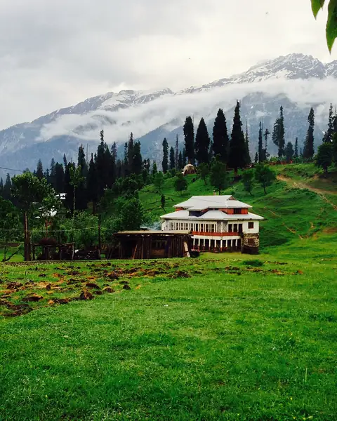
A chalet on a green meadow with snow peaks at Arang Kel

Neelum Valley, Azad Jammu and Kashmir

Arang Kel

A small meadow village on a high ridge above the Neelum River, reached by a cable car and a steep uphill walk.

Altitude
2,554 m
Best months
May–Oct
Level
Moderate
Fly into
Islamabad (ISB)

Overview

Arang Kel is a hamlet of wooden huts on a green plateau high above the Neelum River, near the village of Kel. Pines and tall trees edge the meadow, and snow peaks fill the skyline. There are no roads to the village, so everything arrives on foot or by cable car and on the backs of people and animals.

Visitors cross the river by a cable car (a kind of chairlift) from Kel, then walk a steep path uphill through forest and fields, which takes anything from half an hour to two hours depending on the route and pace. At the top are guesthouses and tents, with simple meals and wide views. It is a quiet place of mist, grass and clear sky, and a favourite with domestic visitors.

Highlights

  • The cable car over the Neelum River at Kel
  • A steep walk up through forest to the meadow village
  • Wooden huts, pine trees and snow peaks
  • Sunrise and sunset from the upper meadows

Best time to visit

May to October is the main season. July and August are the busiest, with cool nights, and the path can be wet and muddy after rain. Snow closes the area in winter.

  1. JanJanuary: Not ideal
  2. FebFebruary: Not ideal
  3. MarMarch: Not ideal
  4. AprApril: Not ideal
  5. MayMay: Good
  6. JunJune: Best
  7. JulJuly: Best
  8. AugAugust: Best
  9. SepSeptember: Best
  10. OctOctober: Good
  11. NovNovember: Not ideal
  12. DecDecember: Not ideal

● Best · ○ Good · blank: not ideal. Conditions vary by year, so check local forecasts and access before you go.

Getting there

Fly to Islamabad (ISB), then drive to Muzaffarabad, then along the Neelum Valley road via Sharda to Kel, about seven to eight hours in total. From Kel, take the cable car across the river and walk up to Arang Kel, which takes an hour or two.

What to expect

The walk is steep and can be tiring, especially with luggage, though porters can be hired. Facilities are basic, with simple rooms and tents, and electricity is limited. Rules for visiting border areas can change, so check them first.

Practical tips

  • Travel light and hire a porter in Kel if you have heavy bags.
  • Check current permission rules for the Neelum Valley and the cable car timings.
  • Wear strong shoes, as the path can be steep and slippery.
  • Bring warm clothes: nights are cold even in summer.

Frequently asked questions

How long is the walk to Arang Kel?

Between half an hour and two hours, uphill from the cable car at Kel, depending on the route and your pace. Ask locally for current advice.

Are there hotels in Arang Kel?

There are simple guesthouses and tents. Book through a contact in Kel or Sharda, especially in July and August.

Can I go in winter?

Not normally. Snow closes the area for much of the year.

Official sources

Rules, fees, permits and conditions change. Check the official pages below before you travel.

Photos
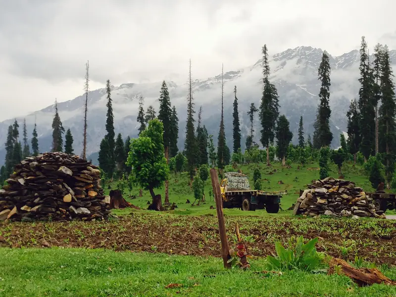
Pines, firewood and mountains at Arang Kel
A cow grazing in the meadow at Arang Kel

Last reviewed October 2026. Details are for planning only and can change; confirm access, permits and conditions with official sources before you travel. Spotted something out of date? Tell us. Photography: Nadeemyasin61 (CC BY-SA 3.0) via Wikimedia Commons, Nadeemyasin61 (CC BY-SA 3.0) via Wikimedia Commons, Nadeemyasin61 (CC BY-SA 3.0) via Wikimedia Commons.

Where to stay

Where to stay in Arang Kel

Hotels in Arang Kel are coming soon

We are adding the hotels, guesthouses and lodges that local owners register with us. Each one is reviewed before it appears here. Meanwhile, you can compare stays on our partner sites.

List your hotel Compare stays (opens a partner site in a new tab)

More in Pakistan

Keep exploring Pakistan

Chitta Katta Lake below dark rock peaks in the Shounter Valley

Shounter Valley, Neelum, Azad Jammu and Kashmir

Chitta Katta Lake

A remote high lake below dark rock peaks and glaciers, reached by jeep from Kel and a long hike in the Shounter Valley.

4,100 m · Jul–Sep · Challenging

Good for: Lakes · Trekking

Forested slopes, a river and village houses in the Neelum Valley

Azad Jammu and Kashmir

Neelum Valley

A deep, green river valley of forest, waterfalls and wooden villages in Azad Kashmir.

2,100 m · May–Oct · Easy

Good for: Scenic views · Lakes

Snow peaks reflected in Ratti Gali Lake in October

Neelum Valley, Azad Jammu and Kashmir

Ratti Gali Lake

A high glacial lake below snow peaks in the upper Neelum Valley, reached by a long walk through meadows from Dowarian.

3,683 m · Jul–Sep · Moderate

Good for: Trekking · Lakes · Scenic views

Sharda village below blue snow-capped mountains in the Neelum Valley

Neelum Valley, Azad Jammu and Kashmir

Sharda

A village in the upper Neelum Valley with a river bridge, wooden cabins and the ruins of an ancient seat of learning.

1,981 m · May–Oct · Easy

Good for: Villages & culture · Scenic views

Dudipatsar Lake in a green bowl of hills

Kaghan Valley, Khyber Pakhtunkhwa

Dudipatsar Lake

A high alpine lake in a green bowl below snow peaks, reached by a long day trek from the Kaghan Valley.

3,800 m · Jul–Sep · Moderate

Good for: Trekking · Lakes · Scenic views

The Neelum River and terraced fields at Keran below blue mountains

Neelum Valley, Azad Jammu and Kashmir

Keran

A village on the Neelum River where the valley opens into terraces and meadows, with guesthouses facing the far bank.

1,524 m · Apr–Oct · Easy

Good for: Scenic views · Villages & culture

Deep blue Lulusar Lake below snow-streaked mountains

Kaghan Valley, Khyber Pakhtunkhwa

Lulusar Lake

A large alpine lake beside the road to the Babusar Pass, and the source of the Kunhar River.

3,410 m · Jun–Sep · Easy

Good for: Lakes · Scenic views

A green valley seen from Babusar Pass

Kaghan Valley to Chilas, Khyber Pakhtunkhwa and Gilgit-Baltistan

Babusar Pass

A high, winding road over the mountains between the Kaghan Valley and the Karakoram Highway, with views towards Nanga Parbat.

4,173 m · Jun–Sep · Moderate

Good for: Scenic views

Snow slopes of Nanga Parbat above the green Rupal Valley

Astore, Gilgit-Baltistan

Rupal Valley

A high valley below the south face of Nanga Parbat, one of the tallest mountain walls in the world, with a trek to the Herrligkoffer base camp.

3,000 m · Jun–Sep · Moderate

Good for: Trekking · Scenic views

The snowy ridge of Nanga Parbat above a dark pine forest

Diamer and Astore, Gilgit-Baltistan

Nanga Parbat

The ninth-highest mountain on earth, an immense snow massif that can be seen from Fairy Meadows, the Rupal valley and the Babusar road.

8,126 m · Jun–Sep · Challenging

Good for: Scenic views · Trekking

A small waterfall among rocks near Athmuqam

Neelum Valley, Azad Jammu and Kashmir

Athmuqam

The main town of the Neelum Valley, with a bazaar, waterfalls and a base for trips to Keran, Sharda and the side valleys.

1,350 m · Apr–Oct · Easy

Good for: Scenic views

Houses among trees above the Jagran River in the Neelum Valley

Neelum Valley, Azad Jammu and Kashmir

Jagran Valley

A green side valley of the Neelum, with clear trout streams, wooden cottages and forests on steep slopes.

1,400 m · Apr–Oct · Easy

Good for: Scenic views

See all 114 places in Pakistan