Skip to content
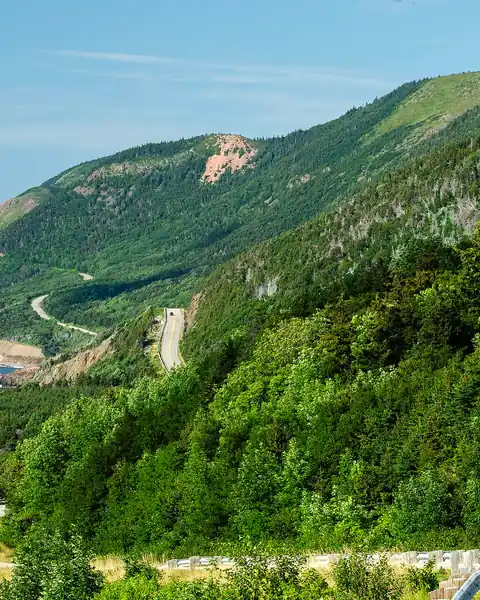
The Cabot Trail winding along the coast of Cape Breton Highlands National Park

Nova Scotia

Cabot Trail and Cape Breton Highlands

A 300 km loop around Cape Breton Island, with cliffs and ocean views, hiking trails and Acadian and Scottish culture.

Altitude
532 m
Best months
Jun–Oct
Level
Easy
Fly into
Sydney (YQY)

Overview

The Cabot Trail is a 300 km scenic road around the northern tip of Cape Breton Island in Nova Scotia, much of it inside Cape Breton Highlands National Park. The road clings to cliffs above the Atlantic and crosses forested highlands, with lookouts at almost every bend.

Trails along the route include the Skyline Trail, where moose and whales may be seen, and many shorter walks to beaches and waterfalls. Villages such as Cheticamp and Ingonish have Acadian and Gaelic culture, with music, restaurants and craft shops. Autumn colours in late September and October are a highlight.

Highlights

  • Cliff-top lookouts along the Cabot Trail
  • The Skyline Trail and other national park hikes
  • Whale watching from Pleasant Bay or Cheticamp
  • Autumn colours in the highlands, and music in local villages

Best time to visit

June to October is the main season. July and August are warm and busy. Late September to mid-October is famous for autumn colour, and a festival of Celtic music takes place in October. Spring is cool, and many services close in winter.

  1. JanJanuary: Not ideal
  2. FebFebruary: Not ideal
  3. MarMarch: Not ideal
  4. AprApril: Not ideal
  5. MayMay: Not ideal
  6. JunJune: Good
  7. JulJuly: Best
  8. AugAugust: Best
  9. SepSeptember: Best
  10. OctOctober: Best
  11. NovNovember: Not ideal
  12. DecDecember: Not ideal

● Best · ○ Good · blank: not ideal. Conditions vary by year, so check local forecasts and access before you go.

Getting there

Fly to Sydney (YQY) or Halifax (YHZ) and drive; Halifax to the start of the trail takes about five hours. A car is the best way to drive the loop, which takes a full day without stops, but two or three days allows time to walk and explore. A Parks Canada pass is required inside the park.

What to expect

Easy. The road is paved and well signed, with sharp bends and steep drops. Short walks are common, and longer trails are moderate. Accommodation can be booked up in July, August and October.

Practical tips

  • Drive the loop clockwise or counterclockwise based on your preference: many people choose counterclockwise for the cliffside lookouts.
  • Book lodging early for July, August and October.
  • Carry a rain jacket, as fog and rain are frequent.
  • Fill up with fuel, as stations can be far apart.

Frequently asked questions

How long does it take to drive the Cabot Trail?

About six hours without stops, but plan two or three days to enjoy the trails and lookouts.

When is the best time for autumn colour?

Usually late September to mid-October, depending on the weather.

Can I see whales?

Yes, on boat tours from Pleasant Bay and Cheticamp, mostly from June to October.

Official sources

Rules, fees, permits and conditions change. Check the official pages below before you travel.

Last reviewed October 2026. Details are for planning only and can change; confirm access, permits and conditions with official sources before you travel. Spotted something out of date? Tell us. Photography: Elviroyage (CC BY-SA 4.0) via Wikimedia Commons.

Where to stay

Where to stay in Cabot Trail and Cape Breton Highlands

Hotels in Cabot Trail and Cape Breton Highlands are coming soon

We are adding the hotels, guesthouses and lodges that local owners register with us. Each one is reviewed before it appears here. Meanwhile, you can compare stays on our partner sites.

List your hotel Compare stays (opens a partner site in a new tab)

More in Canada

Keep exploring Canada

Moraine Lake at sunrise with orange-lit peaks and a turquoise lake

Banff National Park, Alberta

Moraine Lake & Banff

Turquoise water below the Valley of the Ten Peaks; the access road opens in late spring.

1,885 m · Jun–Sep · Easy

Good for: Lakes

Canoes on Lake Louise beneath the Victoria Glacier

Banff National Park, Alberta

Lake Louise

A glacier-fed lake with canoeing in summer and skiing nearby in winter.

1,646 m · Jun–Sep · Dec–Mar · Easy

Good for: Lakes · Snow & ski

Turquoise Maligne Lake below rocky peaks in Jasper National Park

Jasper National Park, Alberta

Jasper and Maligne Lake

A quieter Rockies base with a long turquoise lake, deep canyons and some of Canada's darkest skies.

1,670 m · Jun–Sep · Easy

Good for: Lakes · Scenic views · Trekking

A rocky peak above turquoise Bow Lake beside the Icefields Parkway

Banff and Jasper national parks, Alberta

Icefields Parkway

A 232 km mountain road linking Lake Louise and Jasper, past glaciers, turquoise lakes and waterfalls.

2,088 m · Jun–Sep · Easy

Good for: Scenic views · Lakes · Snow & ski

Red canoes on the shore of Emerald Lake in Yoho National Park

Yoho National Park, British Columbia

Yoho and Emerald Lake

A smaller, steeper park next to Banff, with a bright green lake, a tall waterfall and ancient fossils.

1,282 m · Jun–Sep · Easy

Good for: Lakes · Scenic views · Trekking

Berg Lake and Mount Robson in British Columbia

Mount Robson Provincial Park, British Columbia

Mount Robson

The highest peak in the Canadian Rockies, visible from the Yellowhead Highway, with a famous backpacking trail to Berg Lake.

3,954 m · Jul–Sep · Moderate

Good for: Scenic views · Trekking · Lakes

Snow-covered peaks and cloud above Whistler Blackcomb

British Columbia

Whistler

A car-free mountain village two hours from Vancouver, with huge skiing in winter and lifts, trails and bike parks in summer.

2,182 m · Jun–Sep · Moderate

Good for: Snow & ski · Scenic views · Trekking

Evening light on mountains above Waterton Lake

Waterton Lakes National Park, Alberta

Waterton Lakes

Mountains rising straight from the prairie at the Montana border, with a lakeside village, a historic hotel and rewarding hikes.

1,290 m · May–Sep · Easy

Good for: Lakes · Scenic views · Trekking

Upper Kananaskis Lake below Mount Indefatigable

Alberta

Kananaskis Country

A large mountain playground an hour from Calgary, with blue lakes, high passes and wildlife.

2,206 m · Jun–Sep · Easy

Good for: Lakes · Scenic views · Trekking

A fjord-like lake between steep cliffs in Gros Morne National Park

Newfoundland

Gros Morne

A UNESCO site on Newfoundland's west coast, with fjord-like freshwater ponds, orange rock and dramatic mountain scenery.

806 m · Jun–Sep · Moderate

Good for: Scenic views · Lakes · Trekking

Jagged peaks above tundra in Tombstone Territorial Park

Yukon

Tombstone Territorial Park

Jagged granite peaks and colourful tundra in the Yukon, reached by the Dempster Highway.

2,192 m · Jul–Sep · Moderate

Good for: Scenic views · Trekking · Lakes