Skip to content
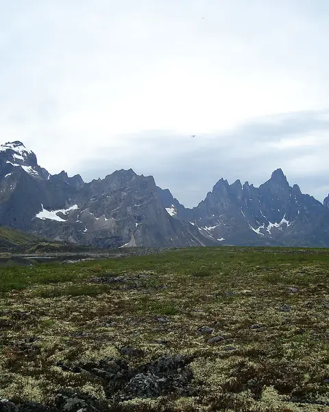
Jagged peaks above tundra in Tombstone Territorial Park

Yukon

Tombstone Territorial Park

Jagged granite peaks and colourful tundra in the Yukon, reached by the Dempster Highway.

Altitude
2,192 m
Best months
Jul–Sep
Level
Moderate
Fly into
Whitehorse (YXY)

Overview

Tombstone Territorial Park lies in Canada's north, along the Dempster Highway, about 1.5 hours from Dawson City. Sharp granite spires, wide tundra and braided rivers make it one of the most striking landscapes in the Yukon, and in late summer the tundra turns red, gold and orange.

The park has an interpretive centre, short trails and backcountry routes to alpine lakes such as Grizzly Lake and Talus Lake, with campgrounds and huts for overnight stays. Caribou, grizzly bears and many birds live here, and the northern lights can be seen from late August on clear nights.

Highlights

  • The jagged spires of Tombstone Mountain
  • Colourful tundra in late August and September
  • The Tombstone Interpretive Centre and short walks
  • Backcountry hikes to Grizzly Lake and Talus Lake

Best time to visit

July and August have long days, and the tundra is greenest. Late August to mid-September brings autumn colour and the first northern lights. The park is very cold from October, and facilities close.

  1. JanJanuary: Not ideal
  2. FebFebruary: Not ideal
  3. MarMarch: Not ideal
  4. AprApril: Not ideal
  5. MayMay: Not ideal
  6. JunJune: Not ideal
  7. JulJuly: Good
  8. AugAugust: Best
  9. SepSeptember: Best
  10. OctOctober: Not ideal
  11. NovNovember: Not ideal
  12. DecDecember: Not ideal

● Best · ○ Good · blank: not ideal. Conditions vary by year, so check local forecasts and access before you go.

Getting there

Fly to Whitehorse (YXY) and drive about six hours to Dawson City, or fly to Dawson City (YDA). The park is about 71 km from the start of the Dempster Highway, a gravel road that needs a vehicle with a spare tyre and fuel. Some tour companies offer guided trips.

What to expect

Moderate. The drive is long and the gravel road requires care. Backcountry hikes are rugged, with changeable weather and few facilities. Be prepared for cold, rain and wildlife.

Practical tips

  • Carry two spare tyres, fuel and supplies on the Dempster Highway, and check road conditions before you go.
  • Reserve backcountry campsites and huts in advance.
  • Carry bear spray and a satellite communicator for backcountry travel.
  • Take warm clothes, as snow is possible even in summer.

Frequently asked questions

How far is Tombstone from Dawson City?

About 1.5 hours by road to the interpretive centre.

Is the Dempster Highway safe?

It is a gravel highway that needs careful driving and a good spare tyre. Check conditions with Yukon authorities.

When can I see the northern lights?

From late August on dark, clear nights, with the best chances in September.

Official sources

Rules, fees, permits and conditions change. Check the official pages below before you travel.

Last reviewed October 2026. Details are for planning only and can change; confirm access, permits and conditions with official sources before you travel. Spotted something out of date? Tell us. Photography: Steraw04 at English Wikipedia (CC BY-SA 3.0) via Wikimedia Commons.

Where to stay

Where to stay in Tombstone Territorial Park

Hotels in Tombstone Territorial Park are coming soon

We are adding the hotels, guesthouses and lodges that local owners register with us. Each one is reviewed before it appears here. Meanwhile, you can compare stays on our partner sites.

List your hotel Compare stays (opens a partner site in a new tab)

More in Canada

Keep exploring Canada

Moraine Lake at sunrise with orange-lit peaks and a turquoise lake

Banff National Park, Alberta

Moraine Lake & Banff

Turquoise water below the Valley of the Ten Peaks; the access road opens in late spring.

1,885 m · Jun–Sep · Easy

Good for: Lakes

Canoes on Lake Louise beneath the Victoria Glacier

Banff National Park, Alberta

Lake Louise

A glacier-fed lake with canoeing in summer and skiing nearby in winter.

1,646 m · Jun–Sep · Dec–Mar · Easy

Good for: Lakes · Snow & ski

Turquoise Maligne Lake below rocky peaks in Jasper National Park

Jasper National Park, Alberta

Jasper and Maligne Lake

A quieter Rockies base with a long turquoise lake, deep canyons and some of Canada's darkest skies.

1,670 m · Jun–Sep · Easy

Good for: Lakes · Scenic views · Trekking

A rocky peak above turquoise Bow Lake beside the Icefields Parkway

Banff and Jasper national parks, Alberta

Icefields Parkway

A 232 km mountain road linking Lake Louise and Jasper, past glaciers, turquoise lakes and waterfalls.

2,088 m · Jun–Sep · Easy

Good for: Scenic views · Lakes · Snow & ski

Red canoes on the shore of Emerald Lake in Yoho National Park

Yoho National Park, British Columbia

Yoho and Emerald Lake

A smaller, steeper park next to Banff, with a bright green lake, a tall waterfall and ancient fossils.

1,282 m · Jun–Sep · Easy

Good for: Lakes · Scenic views · Trekking

Berg Lake and Mount Robson in British Columbia

Mount Robson Provincial Park, British Columbia

Mount Robson

The highest peak in the Canadian Rockies, visible from the Yellowhead Highway, with a famous backpacking trail to Berg Lake.

3,954 m · Jul–Sep · Moderate

Good for: Scenic views · Trekking · Lakes

Snow-covered peaks and cloud above Whistler Blackcomb

British Columbia

Whistler

A car-free mountain village two hours from Vancouver, with huge skiing in winter and lifts, trails and bike parks in summer.

2,182 m · Jun–Sep · Moderate

Good for: Snow & ski · Scenic views · Trekking

Evening light on mountains above Waterton Lake

Waterton Lakes National Park, Alberta

Waterton Lakes

Mountains rising straight from the prairie at the Montana border, with a lakeside village, a historic hotel and rewarding hikes.

1,290 m · May–Sep · Easy

Good for: Lakes · Scenic views · Trekking

Upper Kananaskis Lake below Mount Indefatigable

Alberta

Kananaskis Country

A large mountain playground an hour from Calgary, with blue lakes, high passes and wildlife.

2,206 m · Jun–Sep · Easy

Good for: Lakes · Scenic views · Trekking

A fjord-like lake between steep cliffs in Gros Morne National Park

Newfoundland

Gros Morne

A UNESCO site on Newfoundland's west coast, with fjord-like freshwater ponds, orange rock and dramatic mountain scenery.

806 m · Jun–Sep · Moderate

Good for: Scenic views · Lakes · Trekking

The Cabot Trail winding along the coast of Cape Breton Highlands National Park

Nova Scotia

Cabot Trail and Cape Breton Highlands

A 300 km loop around Cape Breton Island, with cliffs and ocean views, hiking trails and Acadian and Scottish culture.

532 m · Jun–Oct · Easy

Good for: Scenic views · Villages & culture · Trekking