Skip to content
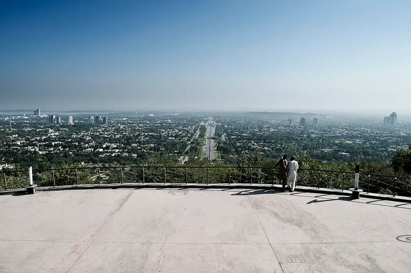
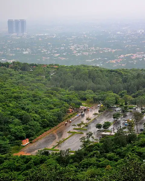
Green forest and the city of Islamabad seen from Daman-e-Koh

Islamabad Capital Territory

Daman-e-Koh

A hillside viewing terrace in the Margalla Hills, with a wide view over Islamabad, its green avenues and the Faisal Mosque.

Altitude
650 m
Best months
Oct–Apr
Level
Easy
Fly into
Islamabad (ISB)

Overview

Daman-e-Koh, meaning "the foothills", is a viewing terrace on the slope of the Margalla Hills, about 10 km from the centre of Islamabad. It was built as a viewpoint, and from its platform you can see the whole city: the grid of tree-lined streets, Rawal Lake, the white spires of the Faisal Mosque and the haze beyond. After dark the city lights glitter below.

A short road climbs from the Margalla road to a car park, and a few cafes and stalls sell tea and snacks. Many visitors come at sunset or on weekend evenings, and the place is also a trailhead for walks into the national park. It is a quick, easy visit and a favourite for families and photographers.

Highlights

  • The panoramic view of Islamabad and the Faisal Mosque
  • Sunset and evening city lights
  • Short walks and trails into Margalla Hills National Park
  • Tea and snacks with a view

Best time to visit

October to April is the best time, with clear air and pleasant temperatures. Summers are hot and often hazy, and the monsoon brings rain and cloud. Sunset gives the best light, and evenings and weekends are busy.

  1. JanJanuary: Best
  2. FebFebruary: Best
  3. MarMarch: Best
  4. AprApril: Best
  5. MayMay: Not ideal
  6. JunJune: Not ideal
  7. JulJuly: Not ideal
  8. AugAugust: Not ideal
  9. SepSeptember: Good
  10. OctOctober: Best
  11. NovNovember: Best
  12. DecDecember: Best

● Best · ○ Good · blank: not ideal. Conditions vary by year, so check local forecasts and access before you go.

Getting there

Fly to Islamabad (ISB) and take a taxi or ride-hailing service to Daman-e-Koh, about 20 to 30 minutes from the centre. The road is paved, and there is a car park at the top. Walkers can also reach it by a trail from the Margalla road.

What to expect

It is a short, simple stop, with limited shade and basic facilities. On busy weekends, traffic and parking can be a problem. Monkeys live around the viewpoint, so keep food out of sight.

Practical tips

  • Go before sunset to see the view in daylight and the city lights afterwards.
  • Keep food hidden from monkeys, and do not feed them.
  • Check opening times and any entry or parking fees.
  • Combine with a short walk on one of the Margalla trails.

Frequently asked questions

What does Daman-e-Koh mean?

It means roughly "the foothills" in Urdu and Persian.

How far is it from the city centre?

About 10 km, or 20 to 30 minutes by road.

When is the best time to go?

Late afternoon, to see the view by day and by night, in the cooler months from October to April.

Official sources

Rules, fees, permits and conditions change. Check the official pages below before you travel.

Photos
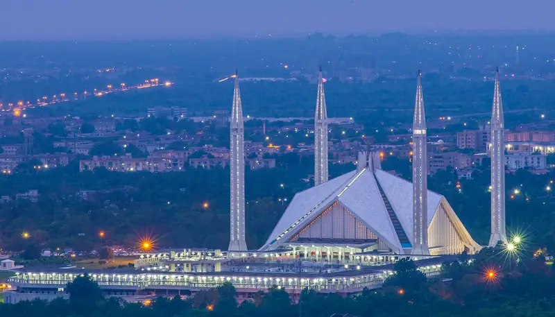
The Faisal Mosque lit at dusk seen from Daman-e-Koh
The viewing terrace at Daman-e-Koh above Islamabad

Last reviewed October 2026. Details are for planning only and can change; confirm access, permits and conditions with official sources before you travel. Spotted something out of date? Tell us. Photography: Obaid747 (CC BY-SA 3.0) via Wikimedia Commons, Abdul Baqi (CC BY-SA 3.0) via Wikimedia Commons, Talha Malik (CC BY-SA 4.0) via Wikimedia Commons.

Where to stay

Where to stay in Daman-e-Koh

Hotels in Daman-e-Koh are coming soon

We are adding the hotels, guesthouses and lodges that local owners register with us. Each one is reviewed before it appears here. Meanwhile, you can compare stays on our partner sites.

List your hotel Compare stays (opens a partner site in a new tab)

More in Pakistan

Keep exploring Pakistan

Islamabad seen from the Margalla Hills

Islamabad Capital Territory

Margalla Hills National Park

A national park on the edge of Islamabad, with forested hiking trails, viewpoints and wildlife a short drive from the city centre.

1,600 m · Oct–Apr · Moderate

Good for: Trekking · Scenic views

The Dharmarajika stupa and monastery ruins at Taxila

Rawalpindi, Punjab

Taxila

A UNESCO World Heritage city of Buddhist stupas, monasteries and ancient ruins, about 35 km from Islamabad.

550 m · Oct–Apr · Easy

Good for: Villages & culture

Snow and pine forest at Murree with distant mountains

Murree, Punjab

Murree

The classic hill station of the Pir Panjal foothills, an easy two hours from Islamabad, with the Mall Road, pine forest and winter snow.

2,200 m · Mar–Nov · Easy

Good for: Scenic views · Snow & ski

Cable cars above pines on the Patriata chairlift

Murree, Punjab

Patriata (New Murree)

A forested hilltop above Murree with a chairlift, a cable car and wide views over the foothills.

2,250 m · Apr–Oct · Easy

Good for: Scenic views

Pines and snow-dusted slopes on the Miranjani trek

Galiyat, Abbottabad, Khyber Pakhtunkhwa

Miranjani Trek

A forest and ridge hike to the highest peak of the Galiyat, with wide views over Kashmir and the Himalayan foothills.

2,992 m · Apr–Oct · Moderate

Good for: Trekking · Scenic views

Dark pine forest on misty hills in Ayubia National Park

Galiyat, Abbottabad, Khyber Pakhtunkhwa

Ayubia National Park

A small national park of pine and fir forest in the Galiyat hills, known for its chairlift, walking trails and leopards.

2,400 m · Apr–Oct · Easy

Good for: Scenic views · Trekking

Snow under tall trees at Nathia Gali

Galiyat, Abbottabad, Khyber Pakhtunkhwa

Nathia Gali

A cool pine-forest hill station in the Galiyat hills, with colonial-era buildings and walks, about two and a half hours from Islamabad.

2,500 m · Apr–Oct · Easy

Good for: Scenic views · Villages & culture

Pine forest hills wrapped in cloud above Dunga Gali

Galiyat, Abbottabad, Khyber Pakhtunkhwa

Dunga Gali

A quiet pine-forest hill station in the Galiyat, with the well-known Pipeline Track walk and trails to Miranjani.

2,500 m · Apr–Oct · Easy

Good for: Scenic views · Trekking

A spillway channel and blue water of Tarbela Lake among green hills

Haripur, Khyber Pakhtunkhwa

Tarbela Dam and Lake

One of the largest earth-filled dams in the world, holding back the Indus in a wide reservoir an easy drive from Islamabad.

450 m · Oct–Apr · Easy

Good for: Scenic views · Lakes

A snowy road through pine forest at Thandiani

Abbottabad, Khyber Pakhtunkhwa

Thandiani

A quiet hill station of thick forest above Abbottabad, with cool summers, snow in winter and views across the Himalayan foothills.

2,750 m · Apr–Oct · Easy

Good for: Scenic views · Snow & ski

Banjosa Lake among forest with a row of cabins on the shore

Poonch, Azad Jammu and Kashmir

Banjosa Lake

A quiet man-made lake among pine forest in the Poonch hills, with boats, cabins and walks, close to Rawalakot.

1,981 m · Apr–Oct · Easy

Good for: Lakes · Scenic views

Forested ridges near Rawalakot seen between pine trees

Poonch, Azad Jammu and Kashmir

Rawalakot

The main town of Poonch, set in a green hill valley, and the base for Banjosa Lake, Toli Pir and the pine forests of the district.

1,600 m · Apr–Oct · Easy

Good for: Scenic views · Villages & culture

See all 114 places in Pakistan