Skip to content
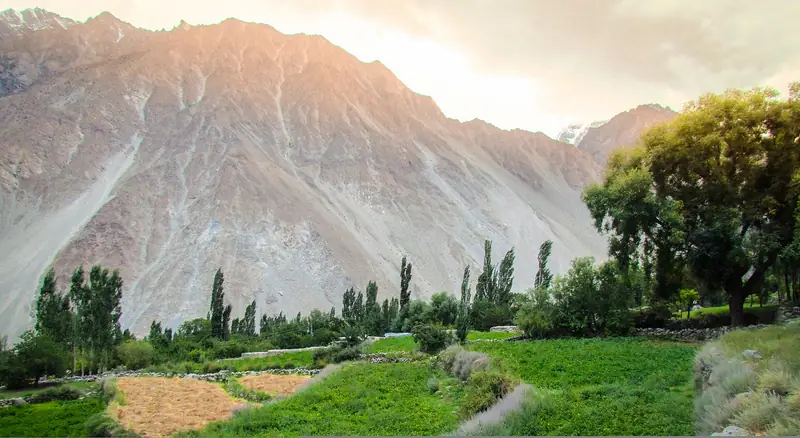
Green fields below sunlit mountains at Gulmit

Gojal, Gilgit-Baltistan

Gulmit and Ghulkin

The main village of upper Hunza, with a small museum, old houses and a glacier on the doorstep of neighbouring Ghulkin.

Altitude
2,500 m
Best months
May–Oct
Level
Easy
Fly into
Islamabad (ISB)

Overview

Gulmit is the largest settlement in Gojal, the upper part of the Hunza Valley, and a good base for exploring the north. The village has old stone and wood houses, a small museum in a traditional building and a bazaar that serves the valley. Most people here speak Wakhi, a language shared with communities across the border.

A short walk or drive away, Ghulkin is a village of dark wooden houses, built close to the Ghulkin Glacier. Trails lead from the village to the glacier and to Borith Lake, and the Passu Cones appear across the valley. The villages are quiet, with orchards, irrigation channels and walnut trees around the houses.

Highlights

  • The museum and the old houses of Gulmit
  • The Ghulkin Glacier, a short walk from the village
  • The trail from Ghulkin to Borith Lake
  • Walnuts, apricots and local meals in family guesthouses

Best time to visit

May to October is the main season. Summer is warm during the day and cool at night, and the autumn leaves colour the valley in October. Winters are cold and most guesthouses close.

  1. JanJanuary: Not ideal
  2. FebFebruary: Not ideal
  3. MarMarch: Not ideal
  4. AprApril: Good
  5. MayMay: Best
  6. JunJune: Best
  7. JulJuly: Best
  8. AugAugust: Best
  9. SepSeptember: Best
  10. OctOctober: Best
  11. NovNovember: Not ideal
  12. DecDecember: Not ideal

● Best · ○ Good · blank: not ideal. Conditions vary by year, so check local forecasts and access before you go.

Getting there

Fly to Islamabad (ISB), then to Gilgit or drive the Karakoram Highway to Hunza. Gulmit is about two hours by road from Karimabad, just beyond Attabad Lake, and Ghulkin is a few kilometres further north. Shared vans and buses run along the highway.

What to expect

Easy, with short walks on village paths and a gentle glacier approach. Guesthouses and small restaurants are simple, with limited electricity in some places. The villages are a good place to slow down after the long drive.

Practical tips

  • Ask your guesthouse about local walks and a guide for the glacier, which has loose stones and hidden hazards.
  • Visit the museum if you are interested in the history and crafts of the valley, and check its opening hours.
  • Respect local customs: dress modestly and ask before photographing people.
  • Cash is needed, and cash machines are limited, so withdraw in Karimabad or Gilgit.

Frequently asked questions

What language is spoken in Gulmit?

Mostly Wakhi, along with Urdu and English among people who work in tourism.

How far is Ghulkin from Gulmit?

About 3 km. You can walk it in an hour or take a short taxi ride.

Is Gulmit a good base?

Yes. From here you can reach Attabad Lake, Ghulkin, Borith Lake and Passu on short day trips, and the border road to Sost is further north.

Official sources

Rules, fees, permits and conditions change. Check the official pages below before you travel.

Photos
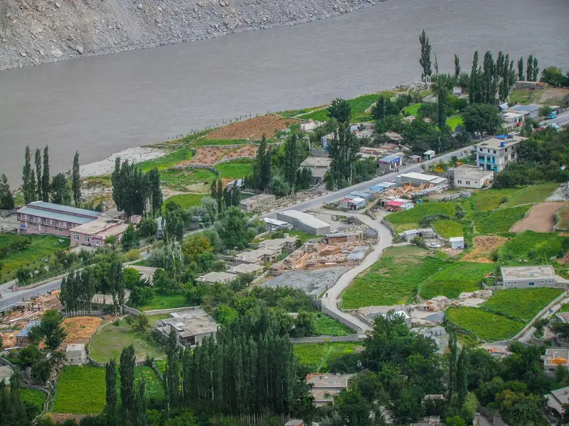
Houses and fields of Gulmit seen from above
Fields and trees at Gulmit under an orange evening sky

Last reviewed October 2026. Details are for planning only and can change; confirm access, permits and conditions with official sources before you travel. Spotted something out of date? Tell us. Photography: Taseer Beyg (CC BY-SA 4.0) via Wikimedia Commons, Taseer Beyg (CC BY-SA 4.0) via Wikimedia Commons, Taseer Beyg (CC BY-SA 4.0) via Wikimedia Commons.
Where to stay

Where to stay in Gulmit and Ghulkin

Hotels in Gulmit and Ghulkin are coming soon

We are adding the hotels, guesthouses and lodges that local owners register with us. Each one is reviewed before it appears here. Meanwhile, you can compare stays on our partner sites.

List your hotel Compare stays (opens a partner site in a new tab)

From the journal

Plan Gulmit and Ghulkin in more depth

More in Pakistan

Keep exploring Pakistan

Borith Lake in a grassy hollow with mountains behind

Near Ghulkin, Gojal, Gilgit-Baltistan

Borith Lake

A small, still lake above the Hunza River, reached by a short walk and a good place to see the Passu Glacier and the cones.

2,600 m · Apr–Oct · Easy

Good for: Scenic views · Lakes

The long rope-and-plank Hussaini Suspension Bridge over the grey Hunza River below rugged peaks

Passu area, Gojal, Gilgit-Baltistan

Hussaini Suspension Bridge

A long rope-and-plank footbridge over the Hunza River, set below the Passu Cones and often photographed as a symbol of the valley.

2,500 m · May–Oct · Easy

Good for: Scenic views · Villages & culture

The jagged Passu Cones rising above the valley

Gojal, Gilgit-Baltistan

Passu

A village below the jagged Passu Cones, with a glacier you can walk to and a famous rope footbridge.

2,500 m · May–Oct · Easy

Good for: Scenic views · Trekking

Turquoise water of Attabad Lake with a small boat and rocky mountain walls

Gojal, Gilgit-Baltistan

Attabad Lake

A long turquoise lake created by a landslide in 2010, now crossed by tunnels and boats on the Karakoram Highway.

2,500 m · Apr–Oct · Easy

Good for: Scenic views · Lakes

Green terraces and a river in the Chhalt valley of Nagar below snow peaks

Nagar, Gilgit-Baltistan

Nagar Valley

The green, terraced valley across the river from Karimabad, with views of Rakaposhi, glaciers and old villages.

2,400 m · Apr–Oct · Easy

Good for: Scenic views · Villages & culture

The stone walls of Altit Fort under a blue sky

Karimabad area, Hunza, Gilgit-Baltistan

Altit

A quiet village of stone houses and orchards around Altit Fort, one of the oldest buildings in the Hunza Valley.

2,100 m · Apr–Oct · Easy

Good for: Villages & culture · Scenic views

Dark cloud and snow on the steep rock faces of Ultar Sar

Above Karimabad, Hunza, Gilgit-Baltistan

Ultar Sar

A 7,388 m peak that rises above Karimabad, with a day walk towards Ultar Meadows and its glacier.

7,388 m · May–Oct · Challenging

Good for: Scenic views · Trekking

Golden poplars beside a turquoise river below Karakoram peaks

Gilgit-Baltistan

Hunza Valley

Apricot orchards, old forts and Karakoram giants along the Karakoram Highway.

2,438 m · Apr–Oct · Easy

Good for: Scenic views · Villages & culture

The wooden balconies and white walls of Baltit Fort against a blue sky

Karimabad, Hunza, Gilgit-Baltistan

Baltit Fort and Karimabad

A restored hilltop fort above Karimabad, the old home of the rulers of Hunza, with sweeping views of the valley and its peaks.

2,500 m · Apr–Oct · Easy

Good for: Villages & culture · Scenic views

Green orchards and snow peaks above the old village of Ganish in Hunza

Karimabad area, Hunza, Gilgit-Baltistan

Ganish

An old stone village beside Karimabad, known for its restored mosques, watchtower and narrow lanes.

2,400 m · Apr–Oct · Easy

Good for: Villages & culture · Scenic views

The Hunza Valley and its poplar trees seen from the Eagle's Nest viewpoint

Above Karimabad, Hunza, Gilgit-Baltistan

Eagle's Nest, Duikar

A hilltop viewpoint above Karimabad with a wide view of the Hunza Valley and the peaks around it.

2,850 m · Apr–Oct · Easy

Good for: Scenic views

A green side valley and braided river below dry mountains in the Hopar area

Nagar, Gilgit-Baltistan

Hopar Valley

A side valley of Nagar where a glacier ends among terraced fields, facing Karimabad across the Hunza River.

2,800 m · May–Oct · Easy

Good for: Scenic views · Villages & culture

See all 114 places in Pakistan