Skip to content
The Gilgit River and the edge of the city under dark mountains

Gilgit, Gilgit-Baltistan

Gilgit

The regional capital and main gateway to Hunza, Naltar, Skardu and the passes, with a lively bazaar and an old Buddhist rock carving nearby.

Altitude
1,500 m
Best months
Apr–Oct
Level
Easy
Fly into
Gilgit (GIL)

Overview

Gilgit is the largest town in Gilgit-Baltistan, a busy bazaar city on the Gilgit River where the main roads of the north meet. It is the place where most journeys turn: north to Hunza and the Khunjerab Pass, east to Skardu and Baltistan, west to Phander and Shandur, and south down the Karakoram Highway to Islamabad.

There is enough to see for a day. The Kargah Buddha, a rock carving of the 7th century or so, stands in a side valley a few kilometres from the city, and the bazaar sells dried fruit, woollen caps and local crafts. Gilgit has a long history on the old Silk Road, and in 1931 a hoard of early Buddhist manuscripts was found nearby. Today the city has hotels, banks, markets and tour operators, and many travellers use it to buy supplies and arrange vehicles.

Highlights

  • The Kargah Buddha rock carving near the city
  • The bazaar, with dried fruit, caps and local crafts
  • River walks and the old bridges over the Gilgit River
  • A base for day trips to Naltar, Bagrot and Hunza

Best time to visit

April to October is the best time. Summers in Gilgit are hot and dry, so the cooler months of April to June and September to October are the most comfortable. Winters are cold, with snow on the surrounding mountains and occasional road delays.

  1. JanJanuary: Not ideal
  2. FebFebruary: Not ideal
  3. MarMarch: Not ideal
  4. AprApril: Best
  5. MayMay: Best
  6. JunJune: Best
  7. JulJuly: Good
  8. AugAugust: Good
  9. SepSeptember: Best
  10. OctOctober: Best
  11. NovNovember: Not ideal
  12. DecDecember: Not ideal

● Best · ○ Good · blank: not ideal. Conditions vary by year, so check local forecasts and access before you go.

Getting there

Fly to Islamabad (ISB), then on to Gilgit by air when the weather allows, though flights are often delayed or cancelled. By road, the Karakoram Highway from Islamabad takes about 14 to 16 hours, often split with a night at Chilas. Skardu is a long day away by road.

What to expect

Gilgit is a busy, working town rather than a resort, with traffic, dust and heat in summer. Hotels range from simple guesthouses to comfortable mid-range hotels, and shops sell most of what you need for a trip to the mountains.

Practical tips

  • Book flights early and have a back-up plan for road travel, because weather often delays flights.
  • Buy cash, SIM cards and supplies here, as services are thinner in the valleys.
  • Check local advice on road conditions and security before long drives.
  • Start day trips early to avoid the heat and the afternoon wind.

Frequently asked questions

Is Gilgit worth a stay?

For one night or two, yes, as a base to sort out transport and permits and to see the Kargah Buddha and the bazaar. Most travellers then head for Hunza.

How far is Gilgit from Hunza?

About 100 km to Karimabad, around two to three hours by road.

What is the weather like?

Hot in summer and cold in winter, with little rain. Spring and autumn are the most comfortable seasons.

Official sources

Rules, fees, permits and conditions change. Check the official pages below before you travel.

Photos
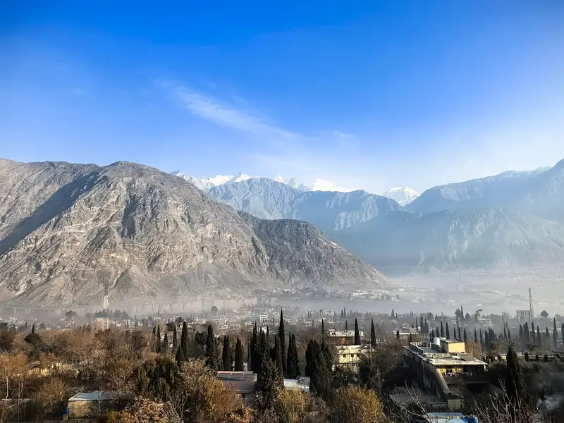
Gilgit city and the dry mountains around it
Gilgit city lights at night seen from the hills

Last reviewed October 2026. Details are for planning only and can change; confirm access, permits and conditions with official sources before you travel. Spotted something out of date? Tell us. Photography: Asad (CC BY-SA 3.0) via Wikimedia Commons, HuangWending18072009 (CC0) via Wikimedia Commons, Imran Shah from Islamabad, Pakistan (CC BY-SA 2.0) via Wikimedia Commons.
Where to stay

Where to stay in Gilgit

Hotels in Gilgit are coming soon

We are adding the hotels, guesthouses and lodges that local owners register with us. Each one is reviewed before it appears here. Meanwhile, you can compare stays on our partner sites.

List your hotel Compare stays (opens a partner site in a new tab)

From the journal

Plan Gilgit in more depth

More in Pakistan

Keep exploring Pakistan

The rock face in Kargah Nala near Gilgit that holds the ancient Buddha carving

Near Gilgit, Gilgit-Baltistan

Kargah Buddha

An ancient standing Buddha carved into a cliff in the Kargah valley, a short drive from Gilgit.

1,500 m · Apr–Oct · Easy

Good for: Villages & culture

Terraced fields and trees of a village in the Bagrot Valley below bare slopes

Near Gilgit, Gilgit-Baltistan

Bagrot Valley

A green side valley about an hour from Gilgit, with terraced villages and trails towards the base of high peaks.

2,300 m · May–Oct · Easy

Good for: Scenic views · Villages & culture · Trekking

Pine slopes and snow peaks reflected in a pool in Naltar Valley

Near Gilgit, Gilgit-Baltistan

Naltar Valley

Pine forest, coloured alpine lakes and winter skiing, a short jeep ride from Gilgit.

2,800 m · Jun–Oct · Easy

Good for: Scenic views · Lakes · Snow & ski

The snowy west face of Rakaposhi above the Hunza Valley road

Minapin, Nagar, Gilgit-Baltistan

Rakaposhi Base Camp

A one- or two-day walk from the village of Minapin to the base camp of Rakaposhi, one of the great mountain walls of the Karakoram.

3,500 m · Jun–Sep · Moderate

Good for: Trekking · Scenic views

The Indus and Gilgit rivers meeting at Jaglot below brown mountains

Gilgit, Gilgit-Baltistan

Jaglot

A roadside junction near Gilgit where the Indus and Gilgit rivers meet and three great mountain ranges come together.

1,400 m · Mar–Nov · Easy

Good for: Scenic views

The green and turquoise water of Satrangi Lake in the Naltar Valley

Naltar Valley, Gilgit, Gilgit-Baltistan

Satrangi Lake

A green-and-turquoise lake in the upper Naltar Valley, reached by a rough jeep track beyond Naltar village.

3,100 m · Jun–Sep · Moderate

Good for: Lakes · Scenic views

A green side valley and braided river below dry mountains in the Hopar area

Nagar, Gilgit-Baltistan

Hopar Valley

A side valley of Nagar where a glacier ends among terraced fields, facing Karimabad across the Hunza River.

2,800 m · May–Oct · Easy

Good for: Scenic views · Villages & culture

Golden poplars beside a turquoise river below Karakoram peaks

Gilgit-Baltistan

Hunza Valley

Apricot orchards, old forts and Karakoram giants along the Karakoram Highway.

2,438 m · Apr–Oct · Easy

Good for: Scenic views · Villages & culture

The wooden balconies and white walls of Baltit Fort against a blue sky

Karimabad, Hunza, Gilgit-Baltistan

Baltit Fort and Karimabad

A restored hilltop fort above Karimabad, the old home of the rulers of Hunza, with sweeping views of the valley and its peaks.

2,500 m · Apr–Oct · Easy

Good for: Villages & culture · Scenic views

Green orchards and snow peaks above the old village of Ganish in Hunza

Karimabad area, Hunza, Gilgit-Baltistan

Ganish

An old stone village beside Karimabad, known for its restored mosques, watchtower and narrow lanes.

2,400 m · Apr–Oct · Easy

Good for: Villages & culture · Scenic views

The Hunza Valley and its poplar trees seen from the Eagle's Nest viewpoint

Above Karimabad, Hunza, Gilgit-Baltistan

Eagle's Nest, Duikar

A hilltop viewpoint above Karimabad with a wide view of the Hunza Valley and the peaks around it.

2,850 m · Apr–Oct · Easy

Good for: Scenic views

The stone walls of Altit Fort under a blue sky

Karimabad area, Hunza, Gilgit-Baltistan

Altit

A quiet village of stone houses and orchards around Altit Fort, one of the oldest buildings in the Hunza Valley.

2,100 m · Apr–Oct · Easy

Good for: Villages & culture · Scenic views

See all 114 places in Pakistan